
Mapping History at the Central Library
Got maps? The downtown library has a passel of great old ones of Buffalo and environs on display. Treasures from the Rare Books Room.
The oldest is from 1795, when the Niagara Frontier was really frontier. It’s by a Philadelphia mapmaker who claims it was “compiled from the best authorities.” It shows “Buffaloe Creek,” but no sign of a settlement in the vicinity. Likewise “Tonewanto Creek.” Fort Niagara is indicated, and the main interest seems to be the road south from the fort, over the escarpment, then heading east southeast toward mid-state. The only road shown. The whole region, from what would become Erie and Niagara counties to east of what would become Rochester is designated “Genessee Country.” (Didn’t the beer—years later—have a similar ad slogan? Updated spelling, of course.)
Two spectacular engraving bird’s-eye-view pictorial maps, showing physical features—buildings, trees, trains, trolleys, horses, people. One looking from lower Main Street, the waterfront, DL&W depot—now NFTA Metro rapid rail transit barns—from the year 1895. The other entitled “The Park, Buffalo, N.Y.: Delaware Park, Lots for Sale,” from 1891. Delaware Park in the foreground, looking north, past the beltline rail line and Hertel Avenue, into Kenmore. Mostly farms north of the park and few scattered houses. But “Delaware Park” is not current Delaware Park. That’s just “The Park.” The “Delaware Park” of the map title is a rectangular territory east of Delaware Avenue, between the beltline and Hertel, extending toward but not all the way to Colvin. This is a prospective sales map. The territory in question is divided into lots on the market. The main selling point, however, is clearly the proximity to the real park. Which looks wonderful without the subsequent expressway disfigurement. The map shows a portion of Humboldt Parkway, before its transformation to an expressway, and a portion of Lincoln Parkway, pretty much as it is today. (But hey, the people on Lincoln Parkway were white. The people on Humboldt Parkway were more and more in the early 1960s black.) Based on the map, Humboldt Parkway was more of a parkway—as wide or wider and more tree-lined—than Lincoln.
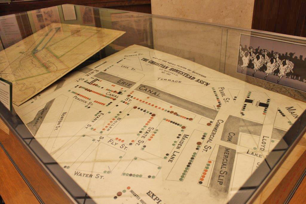
An 1893 map from the Christian Homestead Association of Buffalo (devoted to serving “the unfortunate and erring through mission work”) shows the location of each of the 120 saloons and 75 houses of ill fame in the few blocks area of Canal Town now occupied by the Marine Drive high rise apartments and the Naval and Military Park. A map for newcomers to the area, maybe, pointing out the amenities.
An 1825 Plan of the Village of Buffalo by early local historian Sheldon Ball, who wrote and produced a pamphlet on the village that included the plan—which basically copies Joseph Ellicott’s 1804 layout—and an engraving view of Buffalo Harbor, also on display. A Map of Buffalo Village of 1805, but dating from 1850, when it was drawn by Peter Emslie, the city surveyor, for the Young Men’s Association, the forerunner association to the library, including copious handwritten marginal notes on the history of the village, prior to incorporation as a city in 1832. Another Peter Emslie map is of the Buffalo and Black Rock harbors in 1847. Also, a Frederick Law Olmsted sketch map of his and partner Calvert Vaux’s city parks and parkways system, dated 1874. (They started work on the system in the latter 1860s.)
A map from the Charity Organization Society, listed as from 1896 to 1906, dividing the city into districts within which a designated church congregation would oversee charity distributions. An era when charity was largely or entirely the purview of private usually religious groups. (People who don’t seem real interested in whether poor people get the assistance they need to stay alive and well—even barely—want to go back to this system. I’ve listened to some of them. Basically, no more government social services. Private charity wouldn’t come close to the need.)
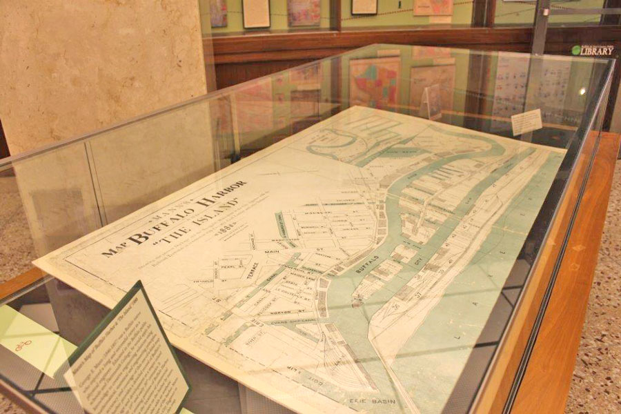
Various other historical maps. A 1907 map of downtown and the canals and waterfront when what we know as the Erie Basin Marina—the land, not the water—was an island. Showing the Union Passenger Station (accommodating the New York Central and half dozen or so other railroads) and Erie Passenger Station and Lehigh Valley Station stood cheek by jowl where the Buffalo News building now stands. Another map of Buffalo Harbor and The Island—that is, Ganson Street milling district—shows the extensive Lehigh Valley slips and docks complex in the Tifft Farm area.
In a piece a couple of weeks ago I quoted Henry Reed’s statement that “maps are of time, not place.” I should have kept it for this one.