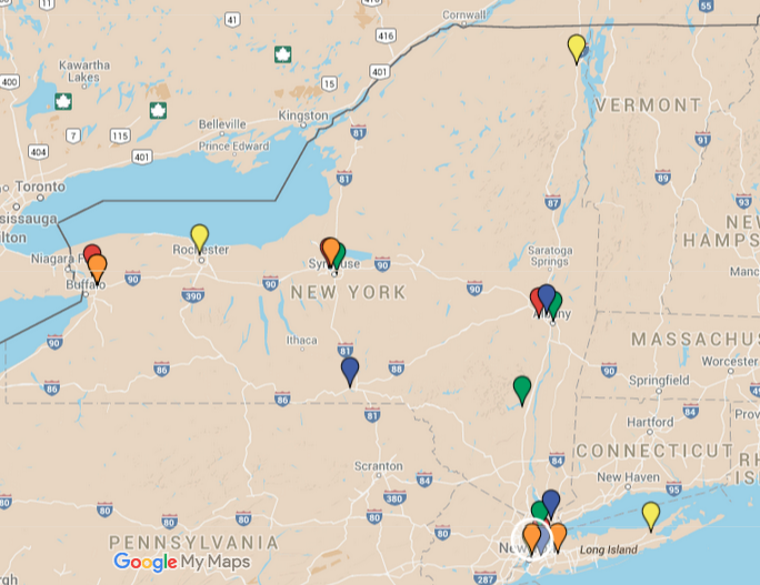
Mapping New York's Marijuana Dispensaries
While the state readies itself for the roll out of its medical marijuana program in January, I’ve become increasingly curious about the locations of the 20 dispensaries, particularly after learning that the two dispensaries that will serve Western New York will both be located in the same town—Amherst.
The data for the locations were culled from the state’s website where applicable, and from other web sites in the case of PharmaCannis, whose application has not yet been posted to the state’s website.
The locations are color coded as follows:
Bloomfield Industries
Columbia Care
Empire Health
Etain
PharmaCannis
As can be seen in the above interactive map, there’s a haphazard nature at times to the geographic placement of dispensaries throughout the state. It makes sense that eight of the dispensaries will be located in the downstate Metro area, but that no dispensaries will be located in Brooklyn or Staten Island seems a bit puzzling. Equally puzzling is the distibution of dispensaries around Albany and Syracuse. Albany County (pop. 304,000) will host three dispensaries in an approximate four-mile radius while Onondaga County (pop. 467,000) will also have three dispensaires in a three-mile radius just east of downtown.
These would seem to be only the first steps in the process to introduce the drug with known benefits to patients who suffer from a host of severe ailments, and most likely does not represent an absolute list. Several groups are advocating with the state for more locations, as requiring a patient in the far northwestern (e.g. Malone, NY) or southwestern (e.g. Jamestown) parts of the state to travel hours by car to receive a potentially life-changing medicine seems especially unreasonable.